ผลการสำรวจ ERT ด้วย Terrameter LS 2 ทางหลวงชนบท จ.นครนายกERT Survey Results with Terrameter LS 2 Rural Highway — Nakhon Nayok Province
✓ กรมทรัพยากรธรณีDept. of Mineral ResourcesABEM Terrameter LS 2
บทความนี้นำเสนอผลการสำรวจหาค่าสภาพต้านทานไฟฟ้าใต้ดิน (ERT) แบบ 2 มิติ จากโปรเจกต์การส่งมอบชุดเครื่องมือ ABEM Terrameter LS 2 แก่กรมทรัพยากรธรณี ในพื้นที่ทางหลวงชนบท ต.ท่าเรือ อ.ปากพลี จ.นครนายก ซึ่งเป็นความร่วมมือระหว่าง Asia Testing Equipment และ Guideline GeoThis article presents 2D ERT (Electrical Resistivity Tomography) survey results from the ABEM Terrameter LS 2 delivery project to the Department of Mineral Resources, conducted along a rural highway in Tha Ruea, Pak Phli, Nakhon Nayok — a collaboration between Asia Testing Equipment and Guideline Geo.
ระยะเวลาเก็บข้อมูลData collection time~40 นาที/แนวสำรวจ~40 min per profile
พื้นที่สำรวจLocationต.ท่าเรือ อ.ปากพลี จ.นครนายกTha Ruea, Pak Phli, Nakhon Nayok
ขั้นตอนการสำรวจSurvey Procedure
การฝึกอบรมประกอบด้วยทั้งภาคทฤษฎีและปฏิบัติ โดยภาคปฏิบัติใช้เครื่อง Terrameter LS 2 สำรวจเก็บข้อมูล ERT แบบ 1, 2 และ 3 มิติ ในที่นี้ขอนำเสนอตัวอย่างการสำรวจแบบ 2 มิติTraining covered both theoretical and practical components. Practical sessions used the Terrameter LS 2 to collect 1D, 2D, and 3D ERT data. This article focuses on the 2D survey results.
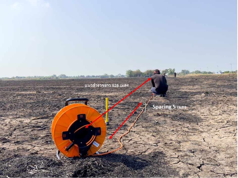
การสำรวจ 2D ใช้การจัดขั้วอิเล็กโตรดแบบ Gradient Array ระยะห่างระหว่างอิเล็กโตรด 5 เมตร โดยสำรวจแบบ Roll-along ขยายแนวสำรวจจาก 420 เมตร เป็น 525 เมตร Terrameter LS 2 แสดงผลแบบ Real-time พร้อมระบบ Remote Control และ GPS ในตัวThe 2D survey used Gradient Array electrode configuration with 5 m spacing. Roll-along technique extended the profile from 420 m to 525 m. Terrameter LS 2 provided real-time display with built-in remote control and GPS.
การสำรวจ ERT ด้วย Terrameter LS 2 ในภาคสนาม จ.นครนายกTerrameter LS 2 ERT field survey — Nakhon Nayokการติดตั้งอิเล็กโตรดตามแนวสำรวจElectrode installation along the survey line
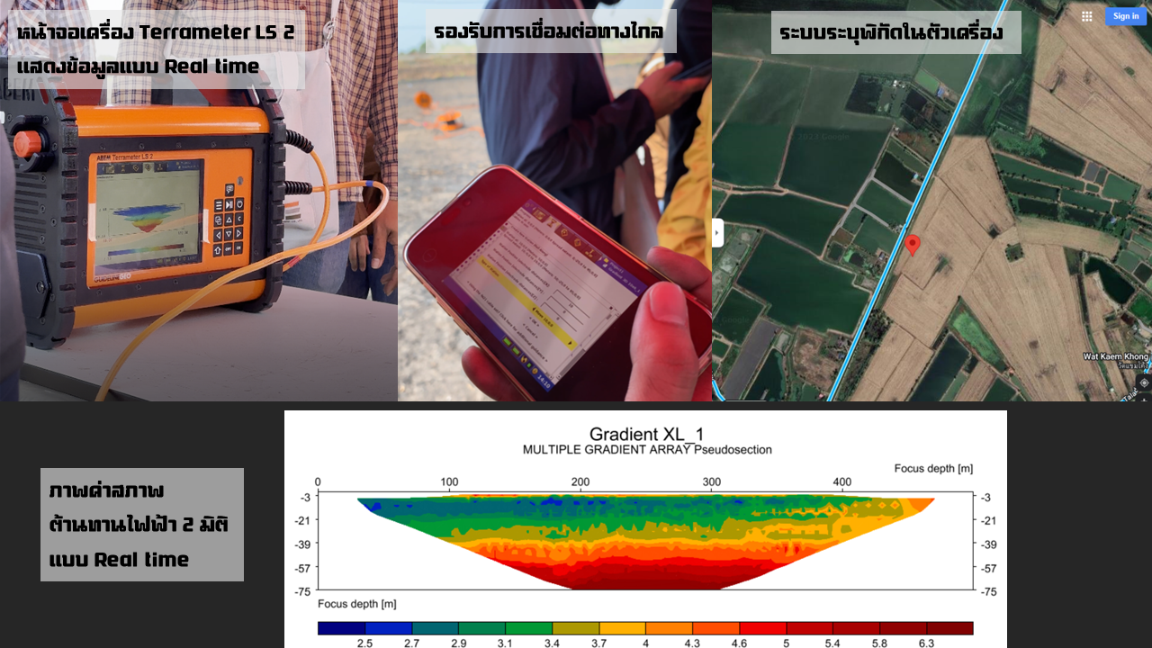
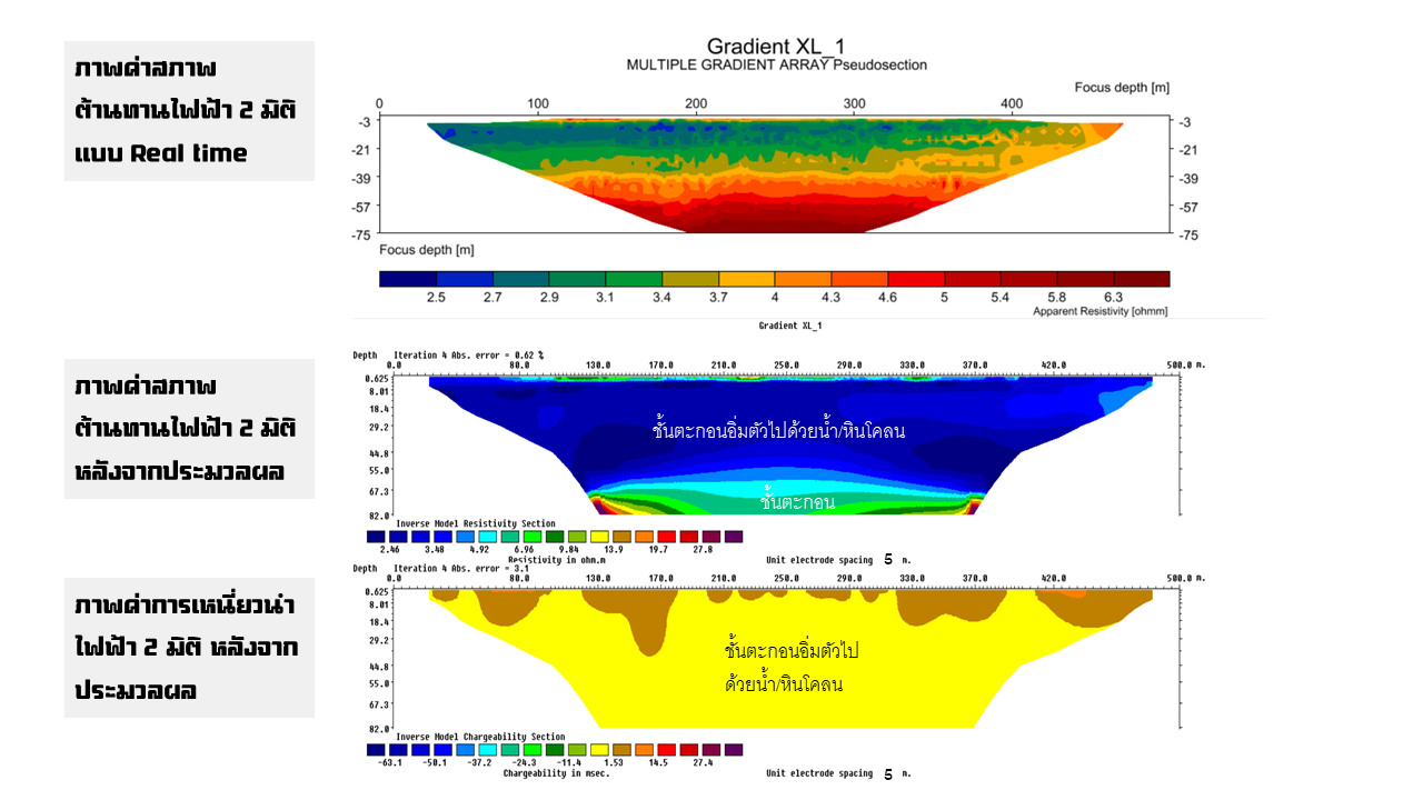
ผลการสำรวจ ERT แบบ 2D2D ERT Survey Results
ผลการสำรวจแสดงค่าสภาพต้านทานไฟฟ้าโดยใช้โปรแกรม Res2dinv ค่าสภาพต้านทานไฟฟ้าอยู่ในช่วง 2–30 โอหม์เมตร ที่ความลึก 75 เมตร แบ่งออกได้เป็น 2 ช่วงหลัก:Survey results processed with Res2dinv show resistivity values ranging from 2–30 Ω·m to a depth of 75 metres, interpreted into two main zones:
🔵 ค่าต่ำกว่า 4 Ω·mBelow 4 Ω·m
แปลความ: ชั้นตะกอนอิ่มตัวด้วยน้ำ หรือหินโคลน ความหนา 0–55 เมตรInterpretation: Water-saturated sediment or mudstone, thickness 0–55 m
🟠 ค่าสูงกว่า 4 Ω·mAbove 4 Ω·m
แปลความ: ชั้นตะกอนหรือหินที่มีความหนาแน่นสูงขึ้น ระดับความลึก 55–75 เมตรInterpretation: Denser sediment or rock layer at 55–75 m depth
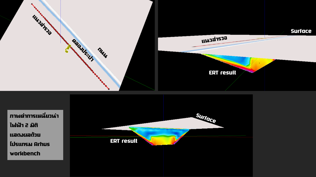
ผลการสำรวจ ERT 2D ประมวลผลด้วย Res2dinv แสดงการกระจายค่าความต้านทานไฟฟ้า2D ERT result processed with Res2dinv showing resistivity distributionการแปลผลชั้นวัสดุใต้ดินจากภาพ ERT 2DSubsurface layer interpretation from 2D ERT imageภาพรวมผลสำรวจตลอดแนว 525 เมตรFull 525 m survey profile overview
ข้อสังเกตจากผลสำรวจKey Observations
ความสามารถของ Terrameter LS 2 ในการสำรวจ ERT และ IP (Induced Polarization) พร้อมกัน ทำให้ได้ข้อมูลที่ครบถ้วนยิ่งขึ้น ระบบ Real-time display ช่วยให้ทีมสำรวจสามารถตรวจสอบคุณภาพข้อมูลได้ทันทีในสนาม และระบบ Remote Control ช่วยลดความเมื่อยล้าจากการสัมผัสกับสภาพแวดล้อมที่ร้อนได้อย่างมากThe Terrameter LS 2's ability to simultaneously collect ERT and IP (Induced Polarization) data provides more complete subsurface information. Real-time display allowed quality control in the field, while the remote control significantly reduced operator fatigue in hot conditions.
สนใจ ABEM Terrameter LS 2?Interested in ABEM Terrameter LS 2?
ATE เป็นตัวแทนจำหน่ายอย่างเป็นทางการในประเทศไทย พร้อมบริการอบรม ฝึกปฏิบัติ และสนับสนุนทางเทคนิคครบวงจรATE is the official distributor in Thailand with comprehensive training, hands-on practice, and technical support.

.png)