GPR (Ground Penetrating Radar) คือเทคโนโลยีสำรวจใต้ดินด้วยคลื่นแม่เหล็กไฟฟ้า ที่ช่วยให้วิศวกรสามารถ มองเห็นสิ่งที่อยู่ใต้ดินโดยไม่ต้องขุด — ไม่ว่าจะเป็นท่อประปา สายไฟ โพรง หรือโครงสร้างคอนกรีต ด้วยความแม่นยำสูงและประหยัดเวลากว่าวิธีดั้งเดิมGPR (Ground Penetrating Radar) is a subsurface investigation technology using electromagnetic waves that allows engineers to see what lies underground without excavation — whether pipes, cables, voids, or concrete structures — with high accuracy and significant time savings.
Non-destructive
ไม่ทำลายพื้นผิวNo excavation needed
0.5–5 m
ความลึกสำรวจได้Survey depth range
Real-time
แสดงผลทันทีInstant results
GPR ทำงานอย่างไร?How Does GPR Work?
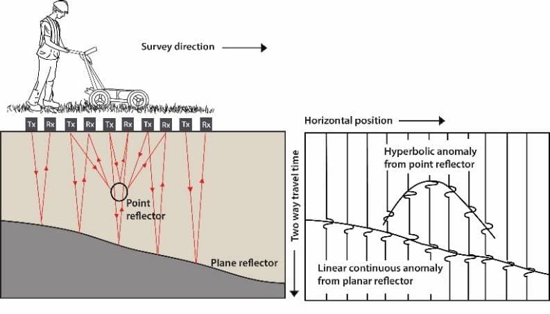
การสำรวจด้วยเทคนิคทางธรณีฟิสิกส์ส่วนใหญ่มักใช้หาวัตถุหรือโครงสร้างที่อยู่ใต้ดินในระดับลึก แต่ในการสำรวจพื้นดินระดับตื้นก็มีการทำกันอย่างแพร่หลายด้วยวิธี Ground Penetrating Radar ซึ่งเป็นวิธีการสำรวจทางวิศวกรรมธรณีฟิสิกส์โดยใช้ คลื่นแม่เหล็กไฟฟ้า (Electromagnetic Wave) ในการตรวจสอบสภาพใต้ดินในระดับตื้น โดยให้ผลภาพที่มีความละเอียดสูงWhile most geophysical survey techniques target deep subsurface targets, GPR is widely used for shallow investigations. The method uses electromagnetic waves to inspect near-surface conditions with high-resolution imagery, making it ideal for civil engineering and infrastructure applications.
หลักการทำงานของ GPR — คลื่นแม่เหล็กไฟฟ้าส่งลงดินแล้วรับสัญญาณสะท้อนกลับGPR principle — electromagnetic waves transmitted into the ground and reflected signals recorded
วิธีการสำรวจด้วย GPR ได้ประสบผลสำเร็จอย่างกว้างขวางในการประยุกต์ใช้งานเพื่อจัดทำแผนที่ของโครงสร้างธรณีวิทยา ตลอดจนถึงการตรวจสอบโครงสร้างคอนกรีต GPR เป็นเครื่องมือที่ทรงประสิทธิภาพสำหรับการสำรวจใต้พื้นดินอย่างละเอียด และยังถูกใช้ในกระบวนการควบคุมคุณภาพงานวิศวกรรมก่อสร้างGPR has proven highly successful in geological structure mapping and concrete inspection applications. It serves as a powerful tool for detailed subsurface surveys and is widely used in construction quality control processes.
ทำไมการระบุตำแหน่งสาธารณูปโภคใต้ดินจึงสำคัญ?Why is Underground Utility Mapping Important?
ระบบสาธารณูปโภคในปัจจุบันมักถูกติดตั้งอยู่ใต้ดิน เมื่อมีการซ่อมแซม ขยาย หรือสร้างถนนใหม่ ข้อมูลแนวท่อเดิมอาจไม่เป็นปัจจุบัน ส่งผลให้การขุดหรือตอกเสาเข็มมีความเสี่ยงสูง ความเสียหายที่เกิดจากการขุดโดนท่อหรือสายไฟมีมูลค่าสูงมาก การสำรวจด้วย GPR จึงเป็นขั้นตอนสำคัญก่อนเริ่มงานก่อสร้างทุกครั้งModern utility systems buried underground may have outdated records when roads are repaired or expanded. Excavating or pile-driving without accurate utility maps poses significant risk. Damage to pipes or cables is extremely costly. GPR surveys have therefore become an essential step before any construction work begins.
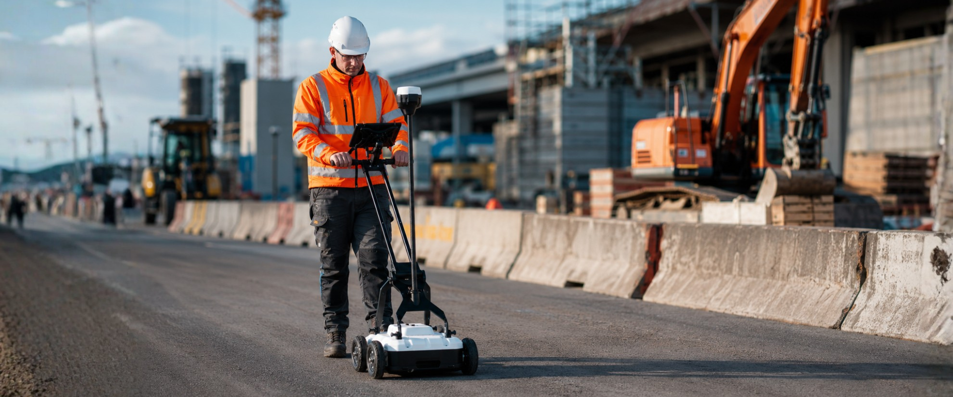
การสำรวจแนวท่อและสาธารณูปโภคใต้ดินด้วย GPR ช่วยลดความเสี่ยงก่อนขุดGPR utility survey helps identify buried pipes and cables before excavation
เครื่อง GPR สามารถค้นหาวัตถุใต้ผิวดินได้ทั้งแบบ โลหะและไม่ใช่โลหะ เช่น ท่อคอนกรีต ท่อเหล็ก หรือวัตถุโบราณ โดยเป็นวิธีการทดสอบแบบไม่ทำลาย (Non-destructive testing) ช่วยลดเวลาและมีราคาประหยัดเมื่อเทียบกับเทคนิคอื่นGPR can detect both metallic and non-metallic underground objects such as concrete pipes, steel pipes, and archaeological artifacts. As a non-destructive testing method, it saves time and is cost-effective compared to other techniques.
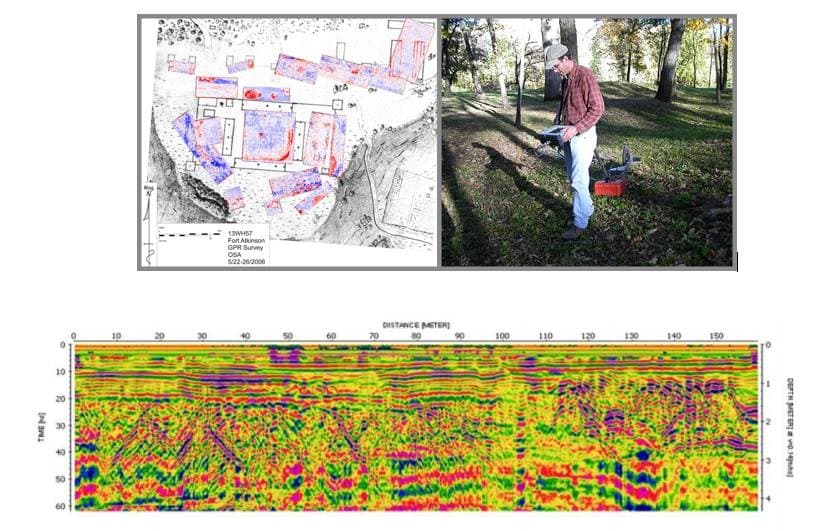
ภาพตัดขวาง (B-scan) จาก GPR แสดงตำแหน่งและความลึกของวัตถุใต้ดินGPR B-scan showing position and depth of subsurface objectsการใช้งานเครื่อง GPR ในภาคสนามGPR equipment in field operation
ข้อดีของการสำรวจด้วย GPRAdvantages of GPR Survey
ครอบคลุมพื้นที่การสำรวจได้กว้าง โดยใช้แบบมือลากหรือแบบติดล้อWide area coverage using hand-pushed or wheel-mounted systems
เก็บข้อมูลได้สะดวก รวดเร็ว ลดเวลาการสำรวจลงอย่างมากFast and convenient data collection, significantly reducing survey time
ให้ความละเอียดสูง มองเห็นรายละเอียดของวัตถุใต้ดินได้ชัดเจนHigh resolution imagery revealing detailed subsurface features
กำหนดความลึกของการสำรวจได้ตามต้องการAdjustable penetration depth to suit survey requirements
แสดงผลกราฟิกจากการสำรวจได้รวดเร็ว (Real-time)Real-time graphical display of survey results
ไม่ทำลายพื้นผิว ปลอดภัย ไม่กระทบโครงสร้างเดิมNon-destructive, safe, and does not affect existing structures
ข้อจำกัดของการสำรวจด้วย GPRLimitations of GPR Survey
การเก็บข้อมูลอาจล่าช้าในพื้นที่ที่มีลักษณะภูมิประเทศลำบากData collection may be slower in areas with difficult terrain
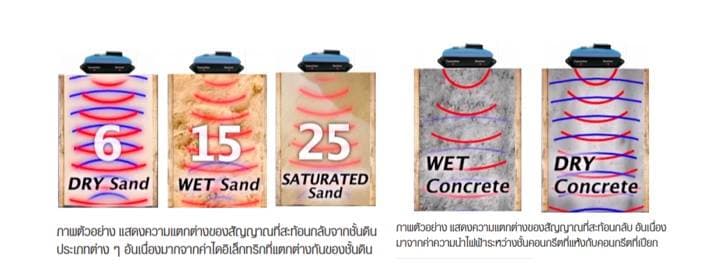
ความลึกถูกจำกัดในวัสดุที่มีค่าการนำไฟฟ้าสูง เช่น ดินเหนียวDepth limited in highly conductive materials such as clay soils
ไม่เหมาะสำหรับพื้นที่ที่มีแนวสายไฟใต้ดินความหนาแน่นสูงNot ideal in areas with dense underground power lines
ไม่เหมาะทำการสำรวจขณะฝนฟ้าคะนองShould not be used during thunderstorms
ไม่เหมาะสำรวจใกล้เสาส่งสัญญาณหรือเสาไฟฟ้าแรงสูง เนื่องจากสัญญาณรบกวนAvoid surveying near transmission towers or high-voltage lines due to interference
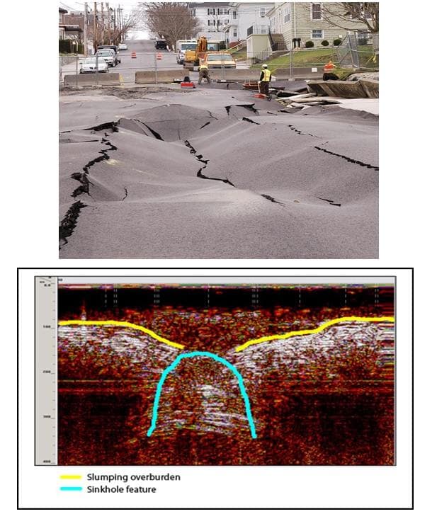
ตัวอย่างการใช้งาน GPR จริงGPR in Action
คำถามที่พบบ่อยFrequently Asked Questions
GPR คืออะไร?What is GPR?
GPR หรือ Ground Penetrating Radar คือเทคนิคการสำรวจใต้ดินด้วยคลื่นแม่เหล็กไฟฟ้า ใช้ตรวจสอบวัตถุ โครงสร้าง หรือชั้นวัสดุใต้ผิวดินแบบไม่ทำลาย เหมาะสำหรับงานวิศวกรรมโยธา งานธรณีฟิสิกส์ และงานตรวจสอบสาธารณูปโภคใต้ดินGPR (Ground Penetrating Radar) is an electromagnetic subsurface investigation technique used to detect objects, structures, or material layers below the surface non-destructively. It is ideal for civil engineering, geophysics, and underground utility inspection.
เครื่อง GPR ใช้ตรวจหาอะไรได้บ้าง?What can GPR detect?
ตรวจหาได้ทั้งท่อ สายไฟ สาธารณูปโภคใต้ดิน โพรง วัตถุทั้งโลหะและไม่ใช่โลหะ โครงสร้างคอนกรีต เหล็กเสริม และความผิดปกติใต้พื้นผิวGPR can detect pipes, cables, utilities, voids, both metallic and non-metallic objects, concrete structures, rebar, and subsurface anomalies.
การสำรวจด้วย GPR ทำลายพื้นดินไหม?Does GPR damage the ground?
ไม่ทำลายครับ GPR เป็น Non-destructive testing ไม่ต้องขุด ไม่กระทบโครงสร้างเดิม เหมาะกับงานสำรวจทุกประเภทNo. GPR is a non-destructive testing method requiring no excavation and causing no impact on existing structures.
GPR สำรวจได้ลึกแค่ไหน?How deep can GPR survey?
โดยทั่วไปสำรวจได้ลึก 0.5–5 เมตรในดินทั่วไป ขึ้นอยู่กับชนิดดินและความถี่ของ Antenna ในดินเหนียวที่มีค่าการนำไฟฟ้าสูงความลึกจะลดลงTypically 0.5–5 metres in general soils, depending on soil type and antenna frequency. In high-conductivity clay soils, the effective depth is reduced.
สนใจบริการสำรวจ GPR หรือซื้อเครื่อง GPR?Interested in GPR Survey Services or Equipment?
ATE ให้บริการทั้งจัดจำหน่ายเครื่อง GPR และรับเหมาสำรวจสาธารณูปโภคใต้ดิน ตอบกลับใน 1 วันทำการATE offers GPR equipment sales and underground utility survey services. Response within 1 business day.

.png)