Resistivity Imaging หรือ ERT (Electrical Resistivity Tomography) คือการสำรวจทางธรณีฟิสิกส์ที่ปล่อยกระแสไฟฟ้าตรง (DC) ลงสู่ดิน แล้ววัดค่าความต่างศักย์ไฟฟ้า เพื่อคำนวณค่าความต้านทานไฟฟ้าจำเพาะของชั้นดิน-หิน สร้างเป็น ภาพตัดขวาง 2D/3D ใต้ดิน ได้อย่างแม่นยำResistivity Imaging or ERT (Electrical Resistivity Tomography) is a geophysical method that injects direct current (DC) into the ground and measures voltage differences to calculate specific resistivity values, creating accurate 2D/3D subsurface cross-sections.
🏔️ เครื่องมือนี้เคยใช้ในปฏิบัติการถ้ำหลวง 2561Used in the Tham Luang Cave Rescue 2018
เครื่อง Resistivity Imaging ถูกนำมาใช้ในปฏิบัติการช่วยเหลือทีมหมูป่าอะคาเดมี่ ถ้ำหลวงขุนน้ำนางนอน เพื่อหาตำแหน่งเส้นทางน้ำใต้ดินและโพรงถ้ำ ช่วยในการวางแผนสูบน้ำและขุดเจาะเข้าไปในถ้ำResistivity Imaging equipment was deployed during the Wild Boars Academy rescue at Tham Luang cave to map underground water pathways and cave voids, supporting pumping operations and drilling entry points.
2D / 3D
ภาพตัดขวางใต้ดินSubsurface cross-section
1–100+ m
ความลึกสำรวจได้Survey depth range
Real-time
แสดงผลในสนามField display
ERT ทำงานอย่างไร?How Does ERT Work?
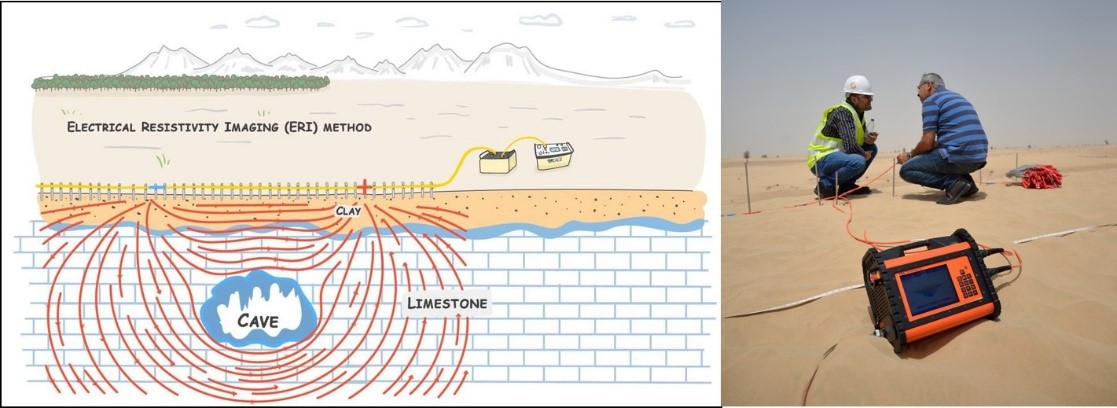
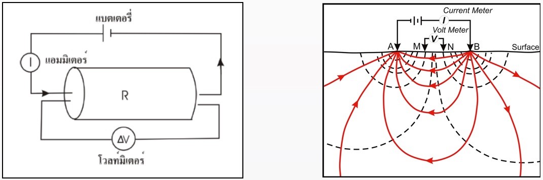
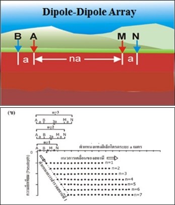
การสำรวจ ERT ใช้การจัดขั้วอิเล็กโตรด (Electrode Array) ตามแนวสำรวจ โดยปล่อยกระแสไฟฟ้าตรงลงสู่ดิน ค่าการเปลี่ยนแปลงของความต่างศักย์ไฟฟ้าและทางเดินกระแสไฟฟ้าจะขึ้นอยู่กับคุณสมบัติของดิน-หิน ซึ่งประกอบด้วยแร่องค์ประกอบ ของเหลวในรูพรุน และองค์ประกอบอื่น ๆERT surveys use an electrode array along the survey line, injecting DC current into the ground. Voltage distribution varies with soil/rock properties — mineral composition, pore fluids, and other components.
การจัดวางอิเล็กโตรดและการสำรวจ ERT ในภาคสนามElectrode array setup and ERT field survey
เมื่อทราบค่ากระแสไฟฟ้าและความต่างศักย์ไฟฟ้าระหว่างขั้วไฟฟ้า สามารถคำนวณค่าความต้านทานไฟฟ้าจำเพาะได้ จากนั้นนำข้อมูลที่ได้ไปประมวลผลด้วยซอฟต์แวร์เช่น Res2dinv เพื่อสร้างภาพตัดขวาง 2 มิติ แสดงการกระจายตัวของค่าความต้านทานไฟฟ้าใต้ดินOnce current and voltage are known, specific resistivity is calculated. Data is processed using software such as Res2dinv to generate 2D cross-section images showing resistivity distribution.
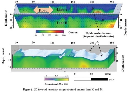
ตัวอย่างผล ERT 2D แสดงค่าความต้านทานไฟฟ้าใต้ดินExample 2D ERT result showing subsurface resistivity distribution
เป้าหมายของการสำรวจ ERTERT Survey Objectives
การสำรวจด้วยวิธี ERT จะไม่ได้สัมผัสกับสิ่งที่ทำการสำรวจโดยตรง แต่อาศัยคุณสมบัติทางกายภาพของวัตถุเป็นตัวบอก วัสดุต่างชนิดกันจะมีค่าความต้านทานไฟฟ้าที่แตกต่างกัน:ERT does not directly contact the survey target but uses the physical properties of materials. Different materials have different resistivity values:
หากกระแสไฟฟ้าไม่สามารถไหลลงดินได้ (เช่น ดินแห้งมาก) จะไม่สามารถสำรวจได้If current cannot flow into the ground (extremely dry soil), surveying is not possible
ค่าความต้านทานต่ำที่ผิวดิน (เช่น ดินเหนียว) อาจกันไม่ให้กระแสไฟฟ้าไหลลึกได้Low surface resistivity (clay layers) may prevent current from reaching depth
การแปลผลต้องอาศัยความเชี่ยวชาญและความรู้ด้านธรณีวิทยาของพื้นที่Interpretation requires expertise and local geological knowledge
เครื่องมือ ERT ที่ใช้งานได้จริงERT Equipment
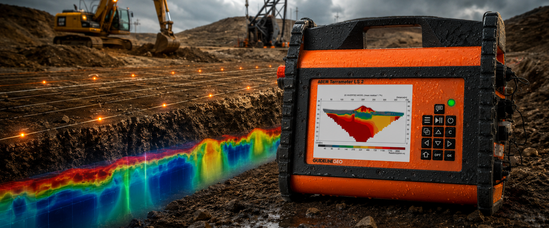
เครื่องมือหลักที่ใช้สำหรับการสำรวจ ERT คือ ABEM Terrameter LS 2 จาก Guideline Geo ซึ่งสามารถสำรวจได้ทั้ง 1D, 2D และ 3D ERT พร้อมวัดค่า IP (Induced Polarization) ได้พร้อมกัน ระบบ Remote Control ช่วยให้สามารถควบคุมการสำรวจจากระยะไกล และ GPS ในตัวช่วยบันทึกพิกัดตำแหน่งโดยอัตโนมัติThe primary instrument used is the ABEM Terrameter LS 2 from Guideline Geo, supporting 1D, 2D, and 3D ERT with simultaneous IP (Induced Polarization) measurement. Built-in remote control and GPS simplify field operations.
ABEM Terrameter LS 2
✓ สำรวจ 1D/2D/3D ERT1D/2D/3D ERT survey
✓ วัด IP พร้อมกันSimultaneous IP measurement
✓ Remote Control
✓ GPS ในตัวBuilt-in GPS
✓ แสดงผล Real-timeReal-time display
✓ รองรับ 4 สาย Roll-along4-cable Roll-along support
Resistivity Imaging คืออะไร?What is Resistivity Imaging?
ERT คือการสำรวจความต้านทานไฟฟ้าจำเพาะใต้ดิน โดยปล่อยกระแสไฟฟ้า DC ลงดินแล้ววัดความต่างศักย์ไฟฟ้า ประมวลผลด้วยซอฟต์แวร์สร้างภาพ 2D/3D ของชั้นวัสดุใต้ดินERT measures subsurface electrical resistivity by injecting DC current and measuring voltage, then processing the data to create 2D/3D images of subsurface materials.
ERT ต่างจาก Seismic Survey อย่างไร?ERT vs. Seismic Survey?
ERT ใช้กระแสไฟฟ้าวัดค่าความต้านทาน เหมาะหาน้ำ มลพิษ และโพรง ส่วน Seismic ใช้คลื่นเสียงวัดความเร็ว เหมาะหาชั้นดิน-หินสำหรับงานฐานราก ทั้งสองวิธีมักใช้ร่วมกันเพื่อผลสำรวจที่ครบถ้วนERT uses electrical current for resistivity mapping, ideal for water, contamination, and voids. Seismic uses acoustic waves for velocity mapping, ideal for soil/rock profiling. Both are often combined.
สนใจเครื่องมือ ERT / Resistivity Imaging?Interested in ERT Equipment?
ATE เป็นตัวแทนจำหน่าย ABEM Terrameter LS 2 อย่างเป็นทางการในประเทศไทย พร้อมบริการอบรมและสนับสนุนทางเทคนิคATE is the official ABEM Terrameter LS 2 distributor in Thailand, with training and technical support services.

.png)