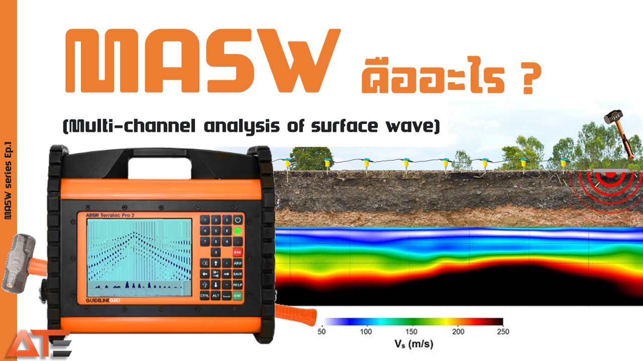
MASW ย่อมาจาก Multichannel Analysis of Surface Waves หรือ การวัดความเร็วคลื่นผิวแบบหลายช่องสัญญาณ เป็นวิธีสำรวจธรณีฟิสิกส์ที่ใช้คลื่นไหวสะเทือนเพื่อประเมินความแข็งของพื้นดิน (Ground stiffness) และโครงสร้างใต้ผิวดิน โดยวัดความเร็วคลื่นเฉือน (Vs) ครอบคลุมความลึก 0–30 เมตร ใช้งานในภาคสนามได้รวดเร็วและไม่ทำลายพื้นที่
MASW stands for Multichannel Analysis of Surface Waves — a geophysical survey method that uses seismic waves to assess Ground stiffness and subsurface structure by measuring Shear Wave Velocity (Vs), covering depths of 0–30 m. It is fast to deploy in the field and completely non-destructive.
วิธีการMethod
Multichannel Analysis of Surface Waves (MASW)
คลื่นที่ใช้Wave Type
คลื่นเรย์ลี (Rayleigh Wave) — คลื่นผิวดินRayleigh Wave (Surface Wave)
ผลลัพธ์Output
โปรไฟล์ Vs แบบ 1D / 2D / ภาพตัดขวาง S-velocity1D / 2D Vs profiles, S-velocity cross-section
ความลึกDepth Range
0 – 30 m
เครื่องมือหลักMain Equipment
Terraloc Pro2 Seismograph, 4.5 Hz Vertical Geophone
🌊 หลักการทำงาน🌊 Working Principle
เมื่อค้อน (Source) ทุบลงแผ่นรองบนผิวดิน จะเกิดคลื่นไหวสะเทือน 2 ชนิด คือ คลื่นตัวกลาง (Body Waves) และ คลื่นผิวดิน (Surface Waves) MASW มุ่งเฉพาะคลื่นเรย์ลี (Rayleigh Wave) เพราะมีคุณสมบัติ การกระจายตัว (Dispersion) — คลื่นเคลื่อนที่ผ่านวัสดุแตกต่างกันด้วยความเร็วต่างกันตามความถี่ คุณสมบัตินี้ทำให้สามารถวิเคราะห์ Dispersion Curve เพื่อหาค่าความเร็วคลื่นเฉือน (Vs) ซึ่งสัมพันธ์กับ Young's Modulus และ Shear Modulus ของชั้นดิน
When a hammer (Source) strikes a plate on the ground surface, two wave types are generated: Body Waves and Surface Waves. MASW focuses exclusively on Rayleigh Waves because of their dispersion property — they travel at different velocities through different materials depending on frequency. This allows analysis of the Dispersion Curve to extract Shear Wave Velocity (Vs), which is related to Young's Modulus and Shear Modulus of soil layers.
หลักการกระจายตัวของคลื่นเรย์ลีในการสำรวจ MASWRayleigh wave dispersion principle in MASW survey.
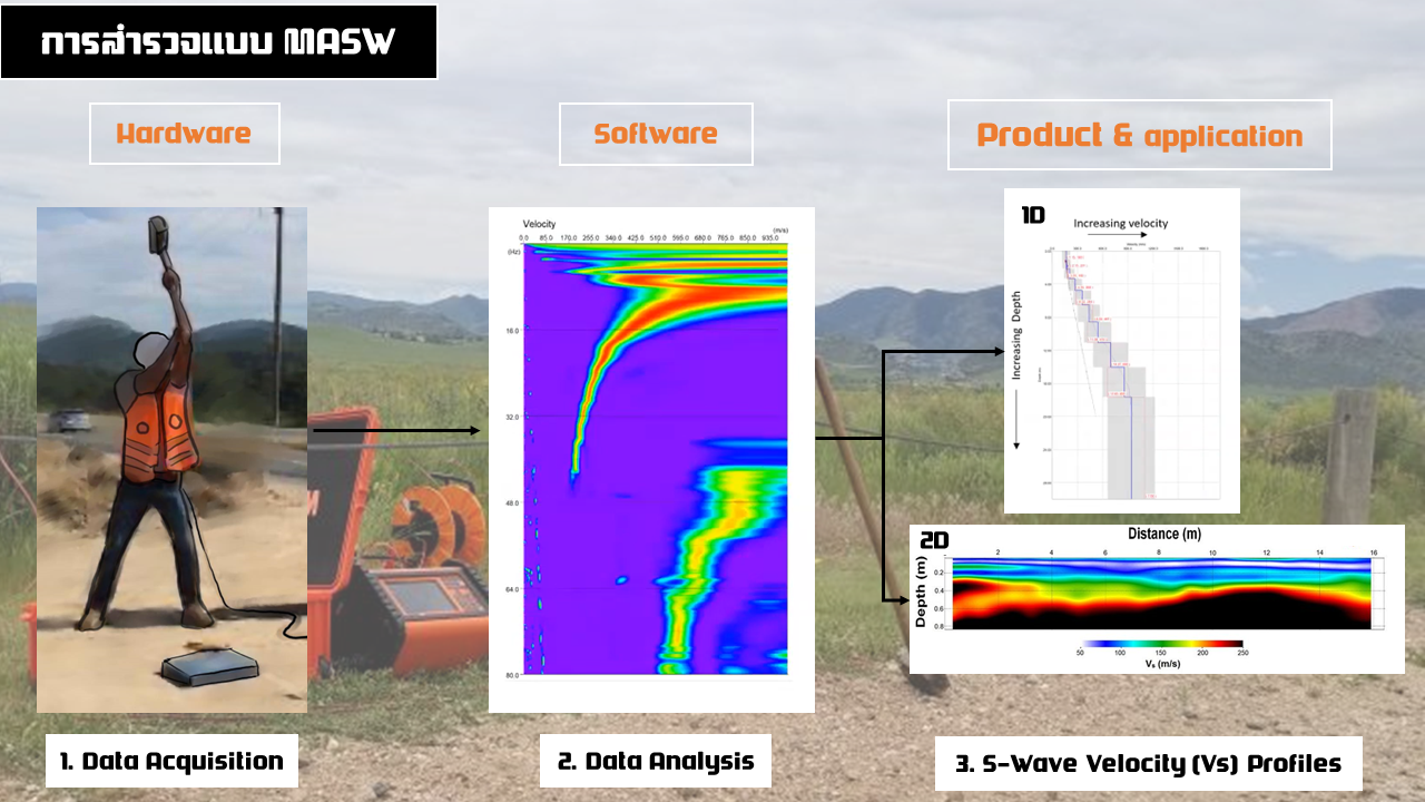
เพื่อสร้างภาพตัดขวาง 2 มิติ จะต้องสำรวจแบบ 1 มิติทีละตำแหน่งแล้วนำข้อมูลมารวมกัน เพื่อสร้างภาพ S-velocity (Vs) แบบ 2D ที่แสดงทั้งระยะทางและความลึก
To build a 2D cross-section, multiple 1D profiles are acquired at successive positions and combined into a 2D S-velocity (Vs) image showing both horizontal distance and depth.
🔧 อุปกรณ์ประกอบการสำรวจ🔧 Survey Equipment
-
แหล่งกำเนิดคลื่น (Source)Source
— ค้อนปอนด์ หรือ Weight Drop ร่วมกับ Trigger สำหรับส่งสัญญาณไปเครื่องบันทึก
— Sledgehammer or Weight Drop with Trigger to synchronise with the recorder
-
อุปกรณ์รับสัญญาณ (Receiver)Receiver
— 4.5 Hz Vertical Geophone
— 4.5 Hz Vertical Geophone
-
เครื่องบันทึกสัญญาณ (Seismograph)Seismograph
— Terraloc Pro2
— Terraloc Pro2
-
อุปกรณ์อื่นๆAccessories
— คอมพิวเตอร์ประมวลผล, แบตเตอรี่ภายนอก
— Processing laptop, external battery
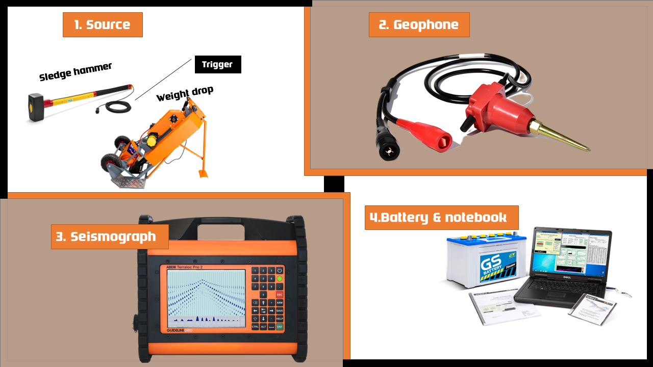
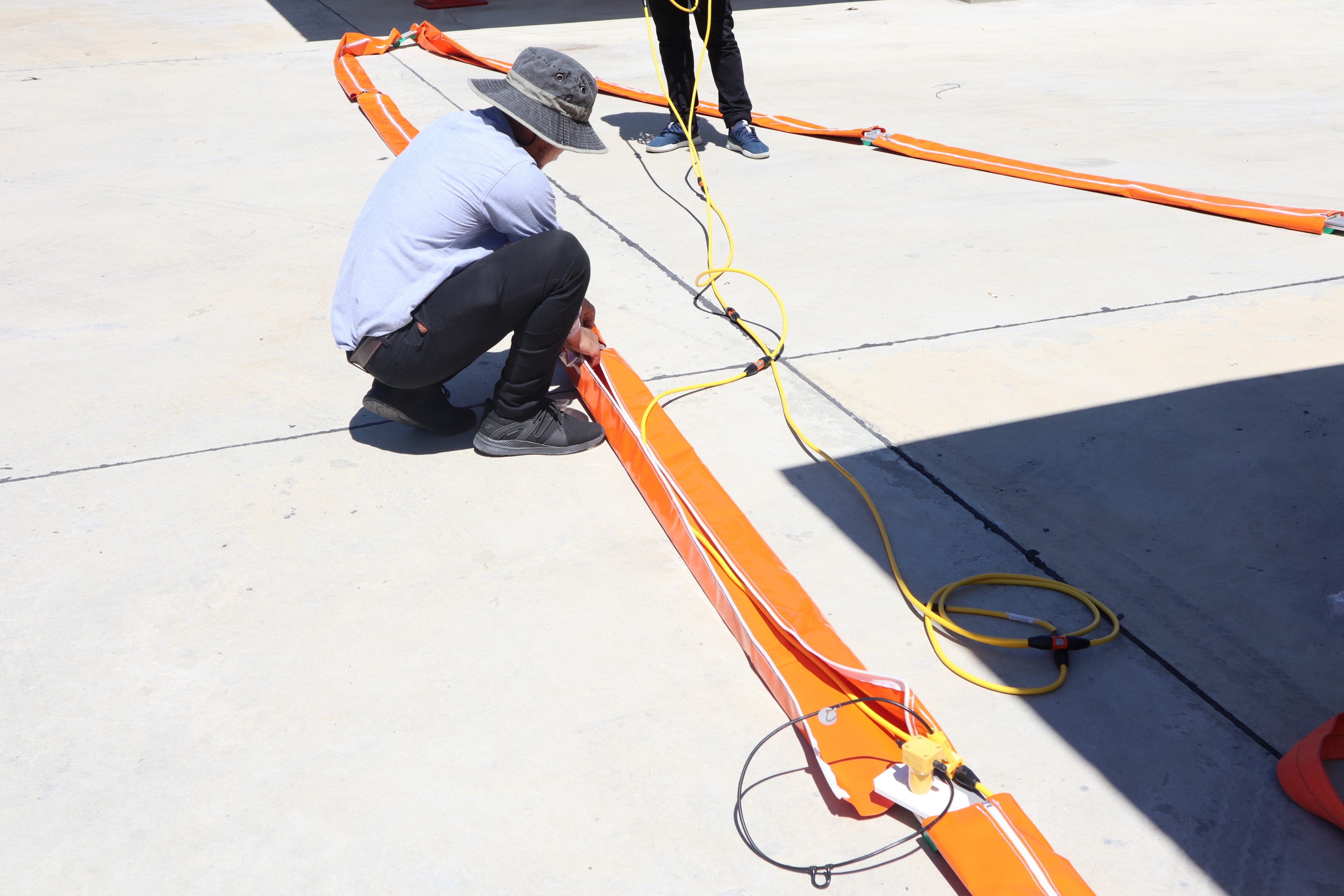
การจัดวางอุปกรณ์สำรวจ MASW — Geophone, Seismograph และแหล่งกำเนิดคลื่นMASW survey equipment layout — Geophone, Seismograph and seismic source.
✅ ข้อดีของ MASW✅ Advantages of MASW
- สำรวจ Vs Profiles แบบ 1D และ 2D ได้อย่างรวดเร็วFast acquisition of 1D and 2D Vs profiles
- เป็นวิธีทดสอบแบบไม่ทำลาย (Non-destructive)Non-destructive test method
- มีประสิทธิภาพแม้ในสภาพแวดล้อมที่มีคลื่นรบกวนสูง เช่น รถวิ่งผ่านEffective even in high-noise environments (e.g. traffic)
- ไวต่อชั้นดินที่มีความเร็วคลื่นเฉือนต่ำ (Low-velocity zones)Sensitive to low-velocity (soft) layers
- ใช้เวลาดำเนินการน้อย สะดวกในการเคลื่อนย้ายQuick to deploy and easy to mobilise
🏗️ การประยุกต์ใช้🏗️ Applications
- ประเมินความแข็งของพื้นดิน (Ground Stiffness)Ground stiffness assessment
- ประเมินโครงสร้างธรณีวิทยาใต้ผิวดินระดับตื้นShallow subsurface geological profiling
- คำนวณ VS30 ตามระบบ NEHRP สำหรับจำแนกประเภทดินเพื่องานแผ่นดินไหวCompute VS30 per NEHRP for seismic site classification
- การสำรวจก่อนขุดเจาะและงาน In-situ TestingPre-drilling investigation and in-situ testing
- Bedrock Mapping — หาระดับชั้นหินBedrock mapping
- การตรวจสอบเขื่อนและคันกั้นน้ำ (Dam & Levee Investigations)Dam and levee investigations
- ตรวจสอบคุณภาพการปรับปรุงดิน (Ground Improvement QA/QC)Ground improvement QA/QC
- ประเมินธรณีเทคนิคชั้นใต้ดินสำหรับงานฐานรากGeotechnical subsurface assessment for foundations
- การประยุกต์ใช้ในงานถนนและโครงสร้างพื้นฐานRoad and infrastructure applications
- ระบุ Weak Zone และความผิดปกติใต้ดินIdentifying weak zones and subsurface anomalies
- ใช้งานได้บนถนน สันเขื่อน และหินแข็ง ด้วยสาย Land StreamerWorks on roads, dam crests, and hard rock with Land Streamer cables
การประยุกต์ใช้ MASW ในงานธรณีเทคนิคและการตรวจสอบโครงสร้างพื้นฐานMASW applied in geotechnical and infrastructure investigation projects.

.png)