Seismic Survey คืออะไร? เครื่องมือสำรวจธรณีฟิสิกส์วัดคลื่นไหวสะเทือนWhat is Seismic Survey? Geophysics Equipment for Subsurface Investigation
อ่าน 7 นาที7 min read
Asia Testing Equipment
การสำรวจวัดคลื่นไหวสะเทือน (Seismic Survey) เป็นวิธีการสำรวจทางธรณีฟิสิกส์ที่มีประสิทธิภาพและเป็นที่นิยมในปัจจุบัน ช่วยให้วิศวกรสามารถ วิเคราะห์โครงสร้างและคุณสมบัติของชั้นดิน-หินใต้ผิวดิน ได้โดยไม่ต้องขุดเจาะ ประหยัดเวลาและค่าใช้จ่ายกว่าวิธีแบบดั้งเดิมมากSeismic Survey is a highly efficient and popular geophysical investigation method that enables engineers to analyze subsurface soil and rock structures without drilling — saving significant time and cost.
Non-invasive
ไม่ต้องขุดเจาะNo drilling
2D / 3D
ภาพตัดขวางใต้ดินSubsurface cross-section
Real-time
ประมวลผลได้ทันทีInstant data processing
Seismic Survey ทำงานอย่างไร?How Does Seismic Survey Work?
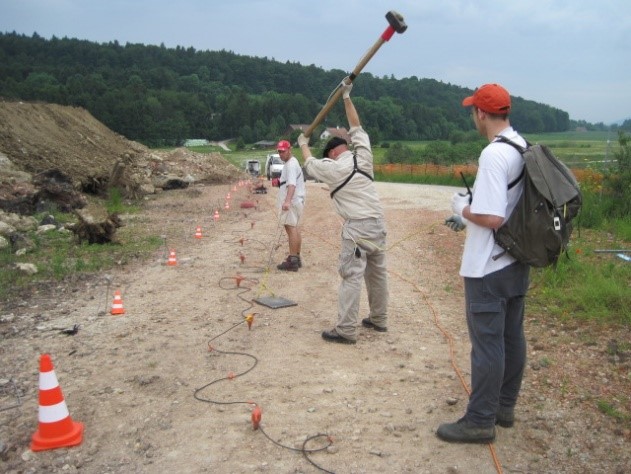
หลักการทำงานคือการสร้างคลื่นไหวสะเทือนที่ผิวดิน (ทุบด้วย Sledgehammer, ระเบิด หรือแหล่งสั่นสะเทือนอื่น) จากนั้นวัดระยะเวลาที่คลื่นเดินทางจากแหล่งกำเนิดไปถึงตัวรับสัญญาณ Geophone ที่ติดตั้งตามแนวสำรวจThe method works by generating seismic waves at the surface (hammer blow, explosion, or vibration source) then measuring the travel time from the source to geophones installed along the survey line.
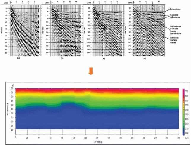
ความเร็วของคลื่นแปรผันตามความหนาแน่นและชนิดของชั้นดิน-หิน ในชั้นที่แน่นและแข็งคลื่นเดินทางเร็ว ในชั้นที่พรุนหรือมีของเหลวแทรกอยู่คลื่นจะช้าลง ข้อมูลนี้ถูกนำมาสร้างภาพตัดขวางของโครงสร้างใต้ดินได้อย่างแม่นยำWave velocity varies with density and type of soil/rock. Dense hard layers transmit waves faster; porous or fluid-saturated layers are slower. This data generates accurate subsurface cross-section images.
Geophone รับสัญญาณคลื่นไหวสะเทือนตามแนวสำรวจGeophones detecting seismic waves along the survey line
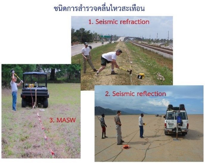
ประเภทของ Seismic SurveyTypes of Seismic Survey
Refraction
ใช้คลื่นหักเห เหมาะหาความลึกหินฐาน และชั้นดินสำหรับงานวิศวกรรมUses refracted waves, ideal for bedrock depth and engineering soil profiles
Reflection
ใช้คลื่นสะท้อน ความละเอียดสูง เหมาะสำรวจโครงสร้างธรณีวิทยาลึกHigh-resolution reflected waves for deep geological structure mapping
MASW
Multi-channel Surface Wave Analysis หาค่า Vs ของชั้นดิน ออกแบบโครงสร้างต้านแผ่นดินไหวMulti-channel Surface Wave Analysis for shear velocity and seismic design
การจัดวาง Geophone ตามแนวสำรวจในภาคสนามField deployment of geophone arrayตัวอย่างผลการสำรวจแสดงโครงสร้างชั้นดิน-หินใต้ผิวดินExample seismic result showing subsurface layer structure
การใช้งาน Seismic SurveyApplications
ออกแบบฐานราก — หาความลึกและประเภทหินฐาน (Bedrock) สำหรับงานก่อสร้างFoundation design — bedrock depth and type determination for construction
สำรวจทรัพยากรธรรมชาติ — ค้นหาแหล่งแร่ น้ำมัน ก๊าซ และแหล่งน้ำบาดาลNatural resource exploration — mineral deposits, oil, gas, and groundwater
ชั้นความเร็วต่ำ (Velocity Inversion) อาจทำให้ผลคลาดเคลื่อนVelocity inversions may cause interpretation errors
คำถามที่พบบ่อยFAQ
Seismic Survey คืออะไร?What is Seismic Survey?
การสำรวจวัดคลื่นไหวสะเทือนทางธรณีฟิสิกส์ โดยสร้างคลื่นที่ผิวดินแล้ววัดเวลาเดินทางถึง Geophone เพื่อวิเคราะห์ชั้นดิน-หินใต้ผิวดินA geophysical method generating seismic waves and measuring travel time to geophones to analyze subsurface soil/rock structure.
MASW คืออะไร?What is MASW?
Multi-channel Analysis of Surface Waves — วิเคราะห์คลื่นพื้นผิวเพื่อหาค่าความเร็วคลื่นเฉือน (Vs) ของชั้นดิน ใช้ออกแบบโครงสร้างต้านแผ่นดินไหวMulti-channel Analysis of Surface Waves for shear wave velocity (Vs) profiling used in earthquake-resistant structural design.
Seismic Survey ต่างจากการเจาะสำรวจอย่างไร?Seismic vs. drilling?
Seismic Survey ไม่ต้องเจาะดิน ครอบคลุมพื้นที่กว้างกว่าในเวลาสั้น แต่การเจาะให้ข้อมูลจุดเฉพาะที่ละเอียดกว่า ทั้งสองวิธีมักใช้ร่วมกันSeismic is non-invasive and covers wider areas faster; drilling provides detailed point data. Both methods are often used together.
สนใจเครื่องมือ Seismic Survey?Interested in Seismic Survey Equipment?
ATE จัดจำหน่ายเครื่องมือสำรวจธรณีฟิสิกส์จาก ABEM และผู้ผลิตชั้นนำ พร้อมทีมผู้เชี่ยวชาญATE distributes geophysical survey equipment from ABEM and leading manufacturers, backed by expert engineers.

.png)